
PROJECT
Improving the Altimeter-Derived Currents With Ocean Colour Data
in the Mediterranean Sea
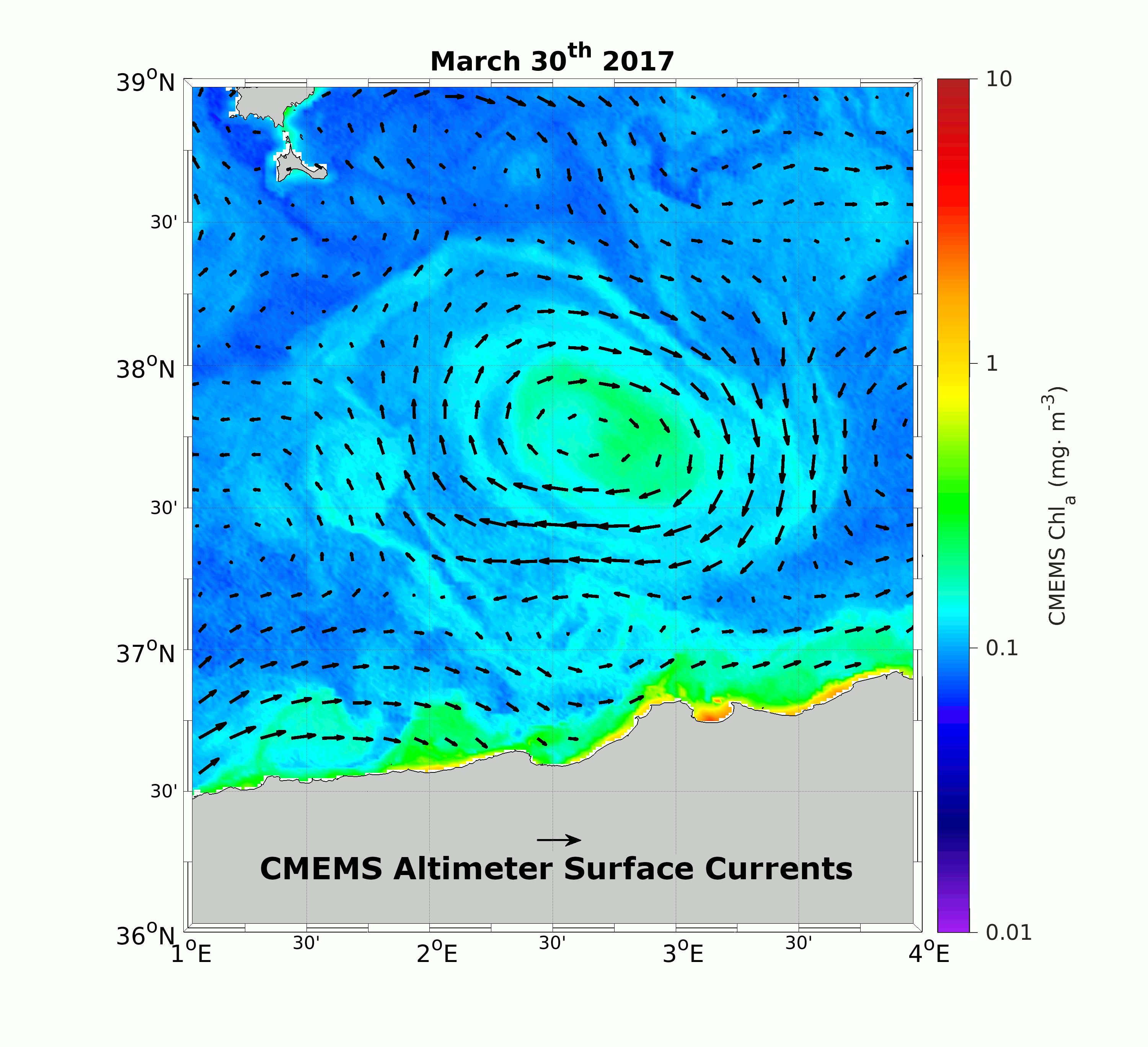 The ocean currents modulate natural and anthropogenic processes at different space and time scales, from global climate change to local dispersal of tracers and pollutants, with relevant impacts on marine ecosystems and maritime activities. Nowadays, radar altimetry provides a space-based estimate of the geostrophic marine surface circulation at an operational level. However, this system has intrinsic limitations related to the effective spatio-temporal resolution of the derived surface currents.The CIRCOL project (ocean CIRculation from ocean COLour observations) aims at retrieving the marine surface currents exploiting the synergy between ocean colour data and the altimeter-derived geostrophic currents. We will determine how the dynamical information contained in the surface chlorophyll concentration (Chl) patterns can improve the present-day surface currents estimates derived from satellite altimetry. Our analyses are based on the Copernicus Marine Environment Monitoring Service (CMEMS) model and satellite-derived data of geostrophic currents and surface chlorophyll concentrations. Our study area is the Mediterranean Sea, a hot-spot for climate change, ecosystem dynamics, ship-routing and safety & rescue activities. A preliminary CIRCOL output is shown by the panel on the right: the CMEMS altimeter-derived surface currents are superimposed to the CMEMS satellite-derived surface Chl in correspondence of an anticyclone detached from the Algerian current (30/03/2017). If the large-scale geostrophic surface circulation is enriched with the dynamical information contained in the Chl patterns, the surface circulation is clearly more in agreement with the patterns of the high-resolution tracer. A quantiative assessment of the synergistic currents will be carried out by means of in-situ derived surface currents, as the one provided by driting buoys or high-frequency radar platforms.
Exploiting the synergy of satellite observations: past achievements
Our investigation relies on past and recent studies based on a mathematical framework derived by Piterbarg 2009 (please check the Bibliography section). The method was firstly applied with success by Rio et al. 2016, Rio and Santoleri 2018 and Ciani et al. 2019 to timeseries of altimeter-derived currents and satellite-derived sea-surface temperature(SST), both at global scale and in the Mediterranean Sea. An example is provided by the figure below, in a test case in the Gulf Stream Area. The figure shows how the information contained in the SST field enables to derive an Optimal Current that corrects the cross-SST-gradient component of the eddy circulation.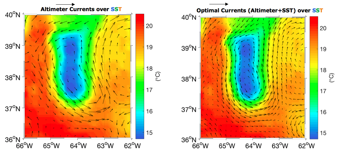
CIRCOL: Work Logic
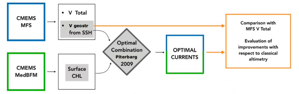
In the CIRCOL project, the feasibility of exploiting ocean colour data to derive the marine surface currents will be tested in the framework of an Observing System Simulation Experiment. In a first analysis (Phase 1), the Piterbarg 2009 method will be applied to the outputs of the CMEMS Mediterranean Forecasting System (MFS) and CMEMS Mediterranean Biogeochemical Flux Model (MedBFM) models. Briefly, these models will provide:• A daily ground-truth surface current estimate in the Mediterranean (for both the zonal and the meridional components)
• A daily Sea-Surface Height (SSH) , from which a set of “simulated” geostrophic currents will be derived
• A set of MedBFM-derived surface Chl concentrations that will be used to implement the Piterbarg 2009 method
The Piterbarg 2009 method will enable to compute a set of optimized currents (Optimal Currents) from the synergy of the “simulated” geostrophic currents and ocean colour data. The quality assessment of the Optimal Currents will be carried out via direct comparison with the MFS model total current (V Total). This OSSE will allow to evaluate how the synergistic currents improve the retrieval of the surface circulation compared to the altimeter estimates. A workflow of Phase 1 is also provided below.
During Phase 2, the same work logic of Phase 1 will be applied to CMEMS satellite-derived datasets of geostrophic currents and satellite-derived surface Chl. In this case, the Optimal Currents quality assessment will be carried out by means of in-situ surface currents estimates as the ones obtained from High-Frequency radar platforms (in coastal areas) or from drifting-buoys measurements.